 MAY 31, 2025
190 miles with 10,200′ climbing
THE BEST RIDES, RACES
AND TOURS ON EARTH !
MAY 31, 2025190 miles with 10,200′ climbing
“Climb the mountains and get their good tidings. Nature’s peace will flow into you as sunshine flows into trees. The winds will blow their own freshness into you, and the storms their energy, while cares will drop away from you like the leaves of Autumn.” -John Muir
Click here to download and print the turn-by-turn route instructions. Since most riders are now using digital GPS navigation, we no longer print route sheets. If you want one, please bring one!
2025 Entry Fees*:
Until May 3: $165
Late entry: May 5- May 24: Make an online reservation and pay $180 cash only at the door.
Last Minute Entry (the week before the ride): $200
Entry includes dinner at Holy Smokes Texas BBQ (limited menu), just down the street from the finish line. Fees increased 3% from 2024 (which doesn’t even come close to covering simple inflation, and the 300%+ increase in event production costs).
Please read our registration and cancellation policies.
* If you’re able to recruit an event volunteer, please email us before signing up and we’ll give you a coupon code to use during registration for an instant 50% off. If you recruit the volunteer AFTER you signed up, we’ll give that volunteer a coupon for 50% discount off a future ride (which you can use if they don’t).
Please READ THE RULES and cancellation policy before signing up!
Click the SignUp button to register online and pay by credit card (processing fees apply). Until May 18th you may click here for instructions to pay by Venmo or Zelle.
We highly recommend purchasing cancellation insurance when you sign up.
Start/Finish Location:
Cielo Hotel, 651 N Main Street in Bishop, 760-873-6381.
Group rates for 2024: $145 plus tax if booked by May 10th; then $155 until May 20th.
This hotel will sell out. Please make your reservation early! Ask for Planet Ultra Cycling rate.
Check-In:
Friday evening from 7:30pm to 8:30pm and Saturday morning from 4:30am to 4:50am at Cielo Hotel.
Start Times:
“Mass” start at 5am for riders needing 13-17 hours to finish. All riders expecting to finish in under 13 hours must start at 6am.
Checkpoint Closing Times Strictly Enforced:
For 2024 we will not have fixed aid stations; but will use leapfrog support.
Checkpoint opening and closing times, listed on the route sheet, are strictly enforced. Typically, only checkpoints #2 and #3 present a problem for slower riders, as the route is front-loaded with climbing. If you miss either CP #2 or CP #3, you’ll be asked to turn around and ride back to Bishop on Highway 395. No exceptions.
Time Limit:
17 hours based on the 5am start time. Course/Finish line closes at 10pm. Please note: Our post-ride dinner at Holy Smokes BBQ ends at 9pm. Please put the hammer down so you can finish in time for dinner!
The course has rolling closures from aid station to aid station.
Aid station closing times are listed on the route sheet. Once an aid station closes, so does support end along the course prior to that aid station. There is no support behind the mileage of a closed aid station. If you’re behind schedule and you need to SAG to the finish, you must find your own way back. Please keep track of where you are on course so this doesn’t happen.
We’ve updated our policy regarding “Tourist” riders. Please read the information and email us if you have questions.
Twilight, Sunrise, and Sunset:
Twilight begins 5:03; Twilight ends 20:41. Sunrise is 5:33; Sunset is 20:11.
Lights and Gear Drop:
If you leave your lights at the start, your bag will be waiting for you in Benton. We do, however, encourage you to carry your lights yourself. That way if you need them, you’re guaranteed to have them. If there’s any chance that you’ll be out past sunset, you MUST have both a headlight and a taillight attached to your bicycle, and you MUST wear a reflective ankle band on both legs.
Lunch Bag Drop:
Because we know some folks have special dietary needs (or are very particular about what they want), you may bring 3 lunch-sized brown paper bags (like the ones you took to school in 2nd grade; and absolutely no larger) filled with your special foods. Drop the bags off at the start, and we’ll deliver them to Crestview, Lee Vining and Benton. Please mark your bag(s) with the location where you want it. Bags will be discarded when the checkpoints close. So please make sure you pick up your bag, or don’t care that you won’t get it back.
Routing and Navigation:
Planet Ultra route sheets include lots of information to help riders navigate the course: Stop sign (SS), traffic light (TL) or T-intersection (T-int). Courses will not be marked. Many of the towns/cities/counties specifically forbid it. More importantly, we believe double century riders are experienced and sophisticated enough to mange navigation. This route is super simple to follow; especially if you have a GPS with turn-by-turn capabilities (which you should have at this level of cycling) and/or a smart phone with RWGPS app.
Please understand and take responsibility for navigation.
Route Sheets and GPS Files:
Route sheets are available in excel format to registered riders if requested via email between 2 weeks and 5 days before the event. We can’t guarantee that advance route sheets will be 100% accurate. Though not anticipated, last-minute routing changes may be required.
Please download the GPS file from RideWithGPS.com. Please further note the following very important caveats:
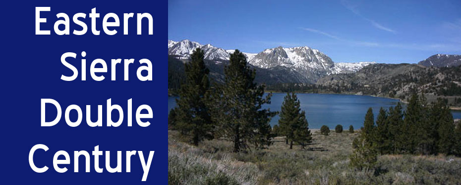
Route Description: A mass start through the city streets of Bishop will quickly head out of town. After a fast, flat warm up heading north through the cattle ranches of Round Valley, the climbing begins in earnest! Ascending up from Round Valley to Crowley Lake, the Old Sherwin Grade winds through pinion pine and juniper woodlands while following Lower Rock Creek to enter Mono County and the heartland of the Eastern Sierra. After cresting Sherwin Grade, a rider friendly 1800′ climb, you are greeted by the startling views of Mt. Ritter and Mt. Banner, and the serrated ridge of the Minarets in the northern distance. North a few miles further awaits Lake Crowley and the grassy bed of Long Valley. Further north en route to Mammoth Lakes, you pass Hilton and McGee Creeks; the mouths of their canyons filled with huge glacial moraines empty into the valley from the Sierra high country.
Leaving Long Valley, you’ll quickly enter the town of Mammoth Lakes, famous for its world class ski resort. You’ll climb gently, but quickly, around the outskirts of town and head out of town and north via the Mammoth Scenic Drive. After a short climb cresting the 8,041′ summit of Deadman Pass, you’ll enjoy a well deserved descent as you head to the June Lake Loop where you’ll enjoy the incredible views of June, Gull, Silver and Grant Lakes.
Once you’re back on 395, you’ll enter “The Land of Mono” as you head to Lee Vining and a nice lunch stop. Enjoy the views of Mono Lake, a million year old body of water ringed by eerie tufa towers, volcanic craters, mountain peaks, and high desert silences. Mono Lake has no outlet; over the thousands of years of its existence, salts and minerals washed into the lake have become concentrated as waters have evaporated. Though Mono Lake has been called a “dead sea”, it actually abounds with life. No fish live in the lake, but populations of brine shrimp and brine flies adapted to the exceptionally high concentration of salts provide a plentiful food supply for more than seventy species of migratory and nesting birds.
Leaving Mono Lake, you’ll head south on Hwy 395 to Hwy 120 through the Mono Crater area. Take time to look around as you climb between these craters en route to the high plains at Sage Hen Summit, through red lava canyons and over to Benton. Then you’ll hang around and ride the flattish Hwy 6 through Chalfant and back to Bishop. Usually a headwind.
This course has about 10,200 feet of elevation gain, more than half of which is between mile 16 and mile 80. As doubles go, it’s not that tough and the views and roads are so incredible, you won’t even notice the climbing that it does have!
Private SAG Vehicles: Not allowed! If you bring one, you’ll be disqualified from the event without a warning. The definition of a personal SAG is any vehicle (motor or otherwise), anywhere on the route, operated by someone other than Planet Ultra staff, that is providing any type of aid, assistance, or motivation, or taking photographs, or simply out cheering. Please understand that our permits simply don’t allow dozens of extra vehicles on the roads or at the checkpoint locations. Imagine the traffic from all those cars! If you’re bringing someone with you who wants to be out on the course, please have them contact us and join our volunteer staff.
Volunteers: We always need volunteers! Click here for info about available positions.