
“KING OF THE MOUNTAINS” CHALLENGE – STAGE #1
Enjoy an epic challenge with tons of climbing in the incredibly beautiful Santa Monica Mountains.
This event is geared toward the adventurous cyclist who loves to climb.
Lots of rides call themselves “the toughest century.” We’ll let you decide!
Metric Century, 3/4 Century and KOM 80 options
NEW KOM Distance Route! 80 miles with 9600′ climbing!
In an effort to be green, we will not print route sheets.
Please print the route sheet for your 2025 distance:
General Information and Ride Rules – Please Read!
E-bikes are welcome, but will not be riding for time or listed in the results.
Click here for 2025 event results.
Click here for the results from prior years.
2025 Entry Fees *:
3/4 Century and KOM 80:
Until April 2: $148.34 ($139 + RunSignUp processing fees, which you may avoid by paying offline)
Late entry: $150 cash with online reservation.
Metric Century:
Until April 2: $137.34 ($129 + RunSignUp processing fees, which you may avoid by paying offline)
Late entry: $130 cash with online reservation.
Entry includes a challenging and rewarding adventure; automatic participation in King of the Mountains Challenge (if you ride the KOM 80 route); route sheet and downloadable RWGPS files with all advance functions; chip timing with overall and age category results posted online; fully stocked checkpoints along the route with a large selection of snacks and drinks; roving SAG support; post ride sandwiches and drinks.
Please read our registration and cancellation policies.
If you’re able to recruit an event volunteer to assist at an aid station or to drive SAG, please email us before signing up and we’ll give you a coupon code to use during registration for an instant 40% off.
NEW KOM route distance! 80 miles with 9600′ climbing.
Please read the rules and our cancellation policy before registering.
Please note: If your 2025 goals include our King of the Mountains Century Challenge, the registration site has an option to sign up for all 3 events at once, with a total discount of $30. That said, the cancellation insurance is not offered with the bundle (so buyer beware).
Start / Finish Location:
2025 host hotel and start/finish: Hampton Inn & Suites, 30255 Agoura Road in Agoura Hills, (818) 597-0333. Please make your reservations using Group Code PUB. Discounted rates expire March 3rd; so please make your reservation early! It’s important that our host hotels know we’re using rooms.
Parking:
Please do not park at the Hampton unless you’re staying there. There is an office complex next door with plenty of parking. Please use the spots closest to the freeway and not immediately adjacent to the buildings. Do NOT park on Agoura Rd. You will be towed away.
Check In:
Friday night from 7:30pm to 8:30pm in lobby at Hampton Inn. Saturday morning from 6am to 7:15am.
START TIMES:
KOM 80 and 3/4 Century Riders: Open starts between 7 and 8am. Here are guidelines based on your expected finishing time:
6-8 hours: 7:00am
under 6 hours: 7:30am.
Metric Riders: Group start at 7:30am. Please no earlier starts. Aid station opening times are based on the 7:30am start.
If you leave before your suggested starting time, you may reach a checkpoint before it opens – and you’ll have to wait, or ride self-supported.
Time Limit:
KOM 80 and 3/4 Century Distance: 8 hours – based on the earliest start at 7am. All riders must be off the course by 3pm.
Metric: 7 hours – based on the 7:30am start.
Chip-Timed Event:
This is not a race – it’s a timed event. You must hang your timing chip facing forward on your handlebars, and you must check in at the finish. If you fail to properly place your timing chip, or don’t pass under the start/finish, you’ll be listed as DNF in the results. Please don’t email us after the event to change your results if you didn’t follow these instructions.
Sticker Stops for KOM riders:
We’re no longer doing stickers. We’ve decided to trust that you are honorable and will ride every inch of the course without modification, or you will admit you didn’t and let us know you DNF. There can only be integrity in our sport if each person is honest about their efforts. We thank you in advance for your trustworthiness. That said, if there’s any disputes or accusations please plan on showing proof of completion via Strava.
Ride Description:
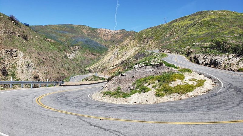
This event is for the cyclist who loves to climb and to see a lot of diverse terrain in the process. Bring gears! Some of the roads have steep sustained climbs of 12-14% with pitches up to 18%. Unless you’re a super strong climber, we suggest at least a 32 cog in the back.
Major Climbs:
Stunt Rd
Westlake Blvd
Yerba Buena
Cotherin Road
Decker Canyon
Fabulous Descents:
Piuma Rd
Yerba Buena
Deer Creek
Westlake Blvd.
80 quad-busting miles with 9600′ feet of climbing; plus shorter options with a bit less climbing.
Route Sheets and GPS Files:
Please note that advance route sheets and gps files are provided as a courtesy and you use them at your own risk. Planet Ultra doesn’t guarantee accuracy. Please further note the following very important caveats:
- A few days before the event, Planet Ultra will email an invitation to the RWGPS “event” with all routes. The links in the invitation allow you to use subscription-based functions even if you only have a free account.
- Never depend solely on a bike mounted GPS. Bring your route sheet, and know how to follow it. Use the RWGPS app on your smart phone as backup.
- Make sure your GPS unit is fully charged.
- Routes (starting/ending at Hampton Inn): These routes are PRELIMINARY. We will send an invitation to view the finalized routes a few days before the ride. Changes ARE possible. Click here to see the KOM 80 Distance map on RideWithGPS.com. Click here for the 3/4 Century map. Click here for the Metric Century.
Routing and Navigation:
Planet Ultra route sheets include lots of information to help riders navigate the course: Stop sign (SS), traffic light (TL) or T-intersection (T-int). We know that riders prefer course markings; however, many of the towns/cities/counties specifically forbid it and in some areas traffic makes it unsafe. Generally speaking, local residents hate it, complain about it every year and even alter the markings on occasion.
For these reasons we will no longer be course marking at our events.
We trust that as a seasoned endurance rider, ready and willing to ride 100 to 200 miles, you’re proficient at reading a route sheet and/or you’ve invested in a GPS based cycling computer into which you can upload the route (and we strongly advise that you use one). Your entry fee includes access to RideWithGPS downloads for your Garmin (or other GPS devise) or your smart phone. The above routes may not be the actual event route; so please download via the event invitation only.
Our experience is that riders get lost whether the course is marked or not; and fewer riders get lost when they’re mindful of where they are on the route sheet. Please understand and take responsibility for navigation. If you are particularly navigationally challenged, please get a GPS or use your smart phone and download the route!
Personal SAG Vehicles:
Not allowed! If you bring one, you’ll be DQ’d without warning. The definition of a personal SAG is any vehicle (motor or otherwise), anywhere on the route, operated by someone other than Planet Ultra staff, that is providing any type of aid, assistance, or motivation, or taking photographs, or simply out cheering. Please understand that our permits simply don’t allow dozens of extra vehicles on the roads or at checkpoint locations. Imagine the traffic from all those cars! If you’re bringing someone with you who wants to be out on the course, please have them contact us and join our volunteer staff.
Volunteers:
We always need volunteers! Click here for info about available positions.
Course Records – CURRENT ROUTE (Since 2016):
WE WILL HAVE NEW RECORDS FOR THE 2025 KOM 80.
Men: Marco Arocha, 5:51:16, Age 40, 2017
Men 50+: Malcolm Hill, 6:16:15, Age 61, 2017
Men 60+: Malcolm Hill, 6:16:15, Age 61, 2017
Men 70+: Greg Kibble, 9:14:04, Age 74, 2017
Women: Mary Dannelley, 6:46:46, Age 48, 2016
Women 50+: Dorina Vaccaroni, 7:28:09, Age 53, 2016
Women 60+: Kathleen House, 9:56:57, Age 65, 2016
Women 70+: Wendy Watson, 10:38:33, Age 72, 2016
Median Finish Time – 8:41:24, 2017
Prior Course Records:
Men – 6:44:03, Nate Whitman, Age 38, 2013
Men 50+ – 6:57:43, Malcolm Hill, Age 55, 2013
Men 60+ – 7:34:28, William Anderson, Age 71, 2014
Men 70+ – 7:34:28, William Anderson, Age 71, 2014
Women – 8:12:55, Heidi Christensen, Age 55, 2013
Women 50+ – 8:12:55, Heidi Christensen, Age 55, 2013
Women 60+ – 10:35:47, Cathy Fritchen, Age 63, 2013
Median Finish Time – 10:06:37, 2013
OLD COURSE INFORMATION: PLEASE DISREGARD EVERYTHING BELOW.
We’re keeping this just in case construction or other issues require us to go back to the old route.
Ride Description:
Note – Route sheets are available in excel format to registered riders if requested via email between 2 weeks and 5 days before the event. However, we can’t guarantee that the route sheet will be 100% accurate. Though not anticipated, last-minute routing changes may be required. Links to the RideWithGPS.com maps and download files are below.
This epic route is as scenic as it is challenging. The course can be described as dramatic, epic, diverse, and beautiful. Ride up, over, and along mountain peaks and ridges, and through a multitude of canyons and country sides. Basically, this event is for the cyclist who loves to climb and to see a lot of diverse terrain in the process. Bring gears! Some of the roads have steep sustained climbs of 12-14% with pitches up to 18%. Unless you’re a super strong climber, we suggest a triple crank, or at least a 30 cog in the back.
Your day starts as you’ll head across Mulholland into the Valley and then hang a right on Topanga. After a fairly gentle climb and a super fast descent, the real climbing begins as you head up and over Old Topanga. Then you’ll tackle Stunt, zip down Piuma back to Mulholland; and take that all the way to the coast. A short ride on PCH takes you to Yerba Buena and Cotharin, before hitting Ventura County and the beach via Deer Creek. After an easy, flat cruise back south on PCH, you’ll climb up Decker Canyon hang a right on Lechusa and climb Encinal Canyon back to Mulholland. From there it’s mostly, but not all, down hill back to Agoura via Cornell. 106 amazing miles with 12,700 feet of climbing.
The 74 miler diverges from the KOM route by taking Encinal to Decker Canyon; and then gets back on the route from there to the finish.
The 58 miler diverges from the KOM route after the second SAG/Sticker Stop at Peter Strauss Ranch.
Route Sheets and GPS Files:
Please note that advance route sheets and gps files are provided as a courtesy and you use them at your own risk. Planet Ultra doesn’t guarantee accuracy. Please further note the following very important caveats:
- The ROUTE SHEET is gospel. Whenever the route sheet and the GPS unit disagree, the route sheet is correct.
- A GPS can (and will) route a rider over a cliff. There’s really no substitute for the human brain, so please use yours.
- Never depend solely on a GPS. Bring your route sheet, and know how to follow it.
- GPS batteries on many “bicycle” GPS units may not last for a century. Make sure you’ve arranged for additional power.
- OLD INFORMATION. DO NOT USE. SEE ROUTE ABOVE. Click here to see the 106 Mile – Full KOM Distance map on RideWithGPS.com . Click here for the 74 Mile map. Click here for the 58 Mile map. You may also download GPS files from this site.
Routing and Navigation:
Planet Ultra route sheets include lots of information to help riders navigate the course. For example, we tell you if a turn is at a stop sign (SS), traffic light (TL) or T-intersection (T-int). We know that riders prefer course markings; however, many of the towns/cities/counties specifically forbid it. Further, your Planet Ultra staff travels to the event destination the day before to make everything happen; so we can’t mark the course in advance. If we have the manpower, we’ll do our best to mark the course (unless it’s forbidden by our permits, otherwise illegal, somewhere that locals would be really upset about it, or the turn is at a place that’s very obvious, like a big green highway sign). Our experience is that riders get lost whether the course is marked or not; and fewer riders get lost when they’re mindful of where they are on the route sheet. Please understand and take responsibility for navigation. If you are particularly navigationally challenged, please get a GPS and download the route!
Parking at Hampton Inn:
If you’re not staying at the Hampton Inn, please do not park in any hotel spots. We’ve secured permission to use parking spaces in the office lot directly next door to the hotel at 30301 Agoura Rd. Please use only the spaces nearest the freeway at the back of the parking lot. Please do not park next to the buildings as some of the tenants are open for business on Saturdays. Thank you for your cooperation and courtesy with the parking situation. If we don’t abide by the request of the office space owners/tenants, we’ll not be allowed to park there next year.