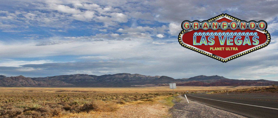
THE LAST HURRAH FOR OUR GRAN FONDO LAS VEGAS!
November 5, 2022
THE PREMIER LAS VEGAS CENTURY EVENT!
Limited to 100 riders
THE BEST RIDES, RACES
AND TOURS ON EARTH !
THE LAST HURRAH FOR OUR GRAN FONDO LAS VEGAS!
THE PREMIER LAS VEGAS CENTURY EVENT!
Limited to 100 riders
General Information and Ride Rules – Please Read!
Click here for the results from prior years.
2022 Entry Fees*:
Mini Fondo – Until October 22: $65. Late entry until 5pm November 4: $75.
Gran & Ultimo Fondo– Until October 22: $95. Late entry until 5pm November 4: $105.
Please read our registration and cancellation policies before signing up.
* If you’re able to recruit an event volunteer, please email us before signing up and we’ll give you a coupon code to use during registration for an instant 50% off. If you recruit the volunteer AFTER you signed up, we’ll give that volunteer a coupon for 50% discount off a future ride (which you can use if they don’t).
Entry includes fully stocked checkpoints along the route with a large selection of snacks and drinks; roving SAG support; entry into Red Rock National Conservation Area and Humbolt-Toiyabe National Forest; Gran Fondo Las Vegas finisher award (guaranteed for those who sign up at least 30 days in advance); discount during event weekend at our sponsor shop, Las Vegas Cyclery; post-ride snacks and refreshments; per rider donation to Life Sports Foundation.
Click the SignUp button to pay by credit card (includes a small service fee). Please read the rules and our cancellation policy before registering.

Event jerseys may be ordered with registration for $80. Guaranteed delivery in Las Vegas if purchased by August 31st. Otherwise, if we don’t have your size, we’ll re-order after the ride and mail your jersey to you. We will have a sizing kit at the event.
Host Hotel:
TDB. Our group rate for 2022 is $?? per night. Let them know you’re with Planet Ultra.
Prior hotel: Element Las Vegas. We’re trying to work with them again for 2022.
The Element Hotel has fantastic rooms which are like a home away from home, with a modern kitchenette (with dinnerware and utensils), a full-sized refrigerator/freezer, coffee maker, microwave, and stovetop burners. There’s a 32″ high-def flat screen tv and dvd player. Free internet access. Delicious breakfast with lots of choices. It’s way nicer, cleaner and more relaxing than a room on the Strip; and right across the parking lot from the start/finish line!
Parking:
If you’re staying at the hotel, by all means, park there! Otherwise park in the lots across the street from the gas station near the Cancer Center. Please do not park at Las Vegas Cyclery unless you’re shopping.
Start / Finish Location:
Las Vegas Cyclery– 10575 Discovery Drive, Las Vegas, NV 89135. Directly next door to our host hotel!
Need to rent a bike or buy last-minute gear? They have you covered!
Check In:
Friday afternoon/evening from 4:30-6pm at Las Vegas Cyclery (on patio behind the shop).
Saturday morning from 6-6:45am at Las Vegas Cyclery in the parking lot.
Chip-Timed Event:
This is not a race – it’s a timed event. You must hang your number plate facing forward on your handlebars, and you must ride through the start/finish arch.
Start Times:
Open start window from 6:45-7am. Less fast riders must start during this 15 minute period, super fast riders may leave as late as 7:15am. We do expect most folks to leave right at 6:45am; so if you like riding in a group, please be ready to roll!
Time Limit:
Course closes at 4pm.
ROUTE INCLUDING SR-160 IS AGAIN OPEN TO BIKES!
Note – Route sheets are available in excel format to registered riders if requested via email between 2 weeks and 5 days before the event. However, we can’t guarantee that the route sheet will be 100% accurate. Though not anticipated, last-minute routing changes may be required. Links to the RideWithGPS.com maps and download files are below.
Gran Fondo Route: 76 miles with about 6,300′ climbing. You’ll enjoy a nice, flat warm-up before you hang a left on Charleston, which becomes Highway 159. It’s a gentle climb to the right turn onto the Scenic Drive heading into Red Rock Canyon. From here the climbing begins. It starts gradually and then pitches up a bit as the scenery becomes more and more beautiful! At the top of the climb you’ll enjoy the view and drinks and snacks at the first checkpoint.
You’ll climb a bit more before you reach the summit – then it’s a wonderful, rewarding descent down to Highway 159 where you’ll make a right. The road rolls gently along Highway 159 all the way to the right turn to Blue Diamond, where you’ll find the second checkpoint. Then you head back to Highway 159 again until you come to the t-intersection at Highway 160, where you’ll turn right.
Here the climbing begins again. About 9 miles of climbing to the summit of Mt. Potosi, a descent to the aid station and a shorter climb back up. Then (mostly) downhill to the finish.
Click here to view the Gran Fondo route map and download-able GPS files.
Ultimo Fondo Route:
Just shy of 100 miles with about 8,000′ climbing. Same as Gran Fondo route with a bonus out and back on Lovell Canyon. Lovell Canyon is an 11-mile, very gentle climb. The return is a straight shot down Highway 160 to the left on Highway 159 and back to Las Vegas Cyclery. Of course you may re-visit the Blue Diamond checkpoint on the way back to refuel and rejuvenate.
Click here for the Ultimo Fondo route and download-able GPS files.
Mini Fondo Route: Just over 43 miles with about 2,800′ climbing. Same start as the Gran and Ultimo Fondo routes, but turns around at Blue Diamond.
Click here for the Mini Fondo route map and download-able GPS files.
Planet Ultra has an “event director” account, so you can get all the RWGPS features even if you’re not a paid subscriber. You can also see the maps and elevation profiles. To take full advantage of all features, use this link.
Routing and Navigation: Planet Ultra route sheets include lots of information to help riders navigate. For example, we’ll let you know if a turn is at a stop sign (SS), traffic light (TL) or T-intersection (T-int). We know riders like to have the course marked; and we do our best to make that happen (unless it’s forbidden by our permits, otherwise illegal, somewhere that locals would be really upset about it, or the turn is at a place that’s very obvious, like a big green highway sign). Many of the towns/cities/counties specifically request that no markings are placed in the road. Some of our permits are contingent on NOT marking turns.
Over the past few years we’ve sadly experienced locals or random drivers removing the arrows or pointing them in the wrong direction after we’ve placed them. So please don’t rely on arrows. You won’t get lost if you’re mindful of where you are on the route sheet. Please understand and take responsibility for navigation. Make it part of your experience. If you’re navigationally challenged, please use a GPS.
Personal SAG Vehicles:
Not allowed! If you bring one, you’ll be disqualified from the event without warning. The definition of a personal SAG is any vehicle (motor or otherwise), anywhere on the route, operated by someone other than Planet Ultra staff, that is providing any type of aid, assistance, or motivation, or taking photographs, or simply out cheering. Please understand that our permits simply don’t allow dozens of extra vehicles on the roads or at the checkpoint locations. Imagine the traffic from all those cars! If you’re bringing someone with you who wants to be out on the course, please have them contact us and join our volunteer staff.
Volunteers:
We always need volunteers! Click here for information about positions available.